
FLAIR — Flood-Level Assessment & Intelligent Response
Solar-assisted riverbed IoT telemetry station concept utilizing ESP32 microcontrollers, ultrasonic depth sensing, and GSM transmission to deliver early flood warnings to a Next.js authority dashboard and Flutter citizen app.
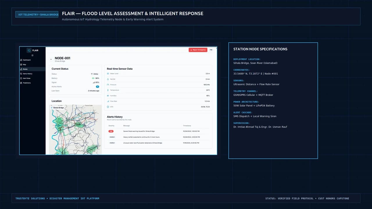
Visual Evidence & Architecture Diagrams
Authentic system diagrams, CAD models, and prototype artifacts documented from technical project reports and live deployments. Click any diagram to inspect full resolution.
 System Schematic
 Technical Blueprint
 Technical Blueprint
 Technical Blueprint
Problem Statement and Solution Architecture
The Problem & Constraints
Flash floods in monsoon-prone river basins frequently wipe out local communication infrastructure, leaving disaster response teams without real-time upstream water elevation data during critical evacuation windows.
The Engineering Solution
Designed a resilient riverbed telemetry station concept using solar-charged battery power, ultrasonic distance transducers, and GSM (SIM800L) cellular data transmission. Developed an authority operations dashboard with statistical 3-sigma anomaly flagging and a mobile notification app.
System Architecture & Operational Workflow
ESP32 edge microcontroller firmware transmitting telemetry payloads over GSM/HTTP to a cloud database (Firebase / Next.js API), consumed by a React/Next.js crisis management portal and Flutter mobile app.
Depth Measurement
Ultrasonic transducer pulses river surface every 60 seconds; firmware computes water elevation.
Cellular Telemetry Packet
Node packages depth, battery voltage, and timestamp into encrypted HTTP payload via SIM800L.
3-Sigma Anomaly Detection
Backend statistical engine compares rate of rise against historical rolling baselines.
Multi-Tier Alerting
If threshold breaches occur, system triggers emergency push alerts and highlights riverbed zones on map.
Key Subsystems & Functional Modules
Detailed breakdown of core software components, algorithms, and automated interfaces engineered for this project.
Edge Power Optimization
ESP32 deep-sleep modes extending battery autonomy during prolonged overcast monsoon weather.
Geospatial Node Status
Map-based overview color-coding river gauge stations as Normal, Elevated, Watch, or Critical.
Citizen Warning Interface
Mobile app notifying residents within proximity of rising river tributaries.
Historical Hydrographs
Interactive water level trend charts helping hydrologists evaluate flood wave propagation.
Applied Technology Stack & Frameworks
Specific libraries, cloud services, and protocols utilized across the development lifecycle.
Hardware & Edge
Cloud & Database
Authority Dashboard
Citizen Client
Engineering Contribution
- Academic capstone project at CUST; contributed to ESP32 firmware sensor sampling and GSM transmission routines, Next.js crisis management dashboard UI, and map visualization components.
Validation & Testing Evidence
- Tested in bench-scale hydraulic tanks and simulated elevation chambers; verified GSM packet delivery across cellular networks; thesis report approved by CUST department faculty.
Technical Scope Transparency & Future Roadmap
TrustByte adheres to rigorous engineering ethics. We explicitly delineate verified production features from simulated models, proposed future integrations, or hardware constraints:
- Designed and tested as an academic proof-of-concept system; physical riverbed deployment requires rugged IP67 enclosures, river authority calibration, and official NDMA/PDMA disaster management integration.
Whether you require an enterprise software portal, custom web platform, mobile application, or embedded hardware telemetry, our engineers are ready to scope your requirements.